The search phrase arrives with a premise baked in: eight charted depths off Peniche, a canyon depth comparison, the implication being that Supertubos owes its shape to the same submarine architecture that aims water at Nazaré's lighthouse forty kilometres north. The premise is wrong, and the wrongness is visible the moment the chart is opened. Peniche sits at 39.3437, -9.362, on a low limestone peninsula pushed into the Atlantic. The seafloor around it slopes. It does not plunge. Any honest reading of the bathymetry starts from that distinction, and this one does.
We drew this coast before we wrote about it. The plotted outline came off OpenStreetMap's natural=coastline layer via Overpass, which is the same ODbL data that populates every honest cartographer's baseplate for this stretch of the Estremadura shore. The coastline traces a peninsula whose western face — the Supertubos face — sits roughly ten metres above a shelving nearshore that continues out at a shallow, monotonically deepening grade. That grade is the entire story. The mistake the query is making is treating "canyon" as a portable explanation, the way people once treated "reef" as the explanation for every wave that broke hard. The seafloor off Peniche is not a canyon. It is a beach shelf with sand on top of it, and the wave that arrives there responds to that fact.
The Query Assumes a Canyon That the Chart Does Not Show
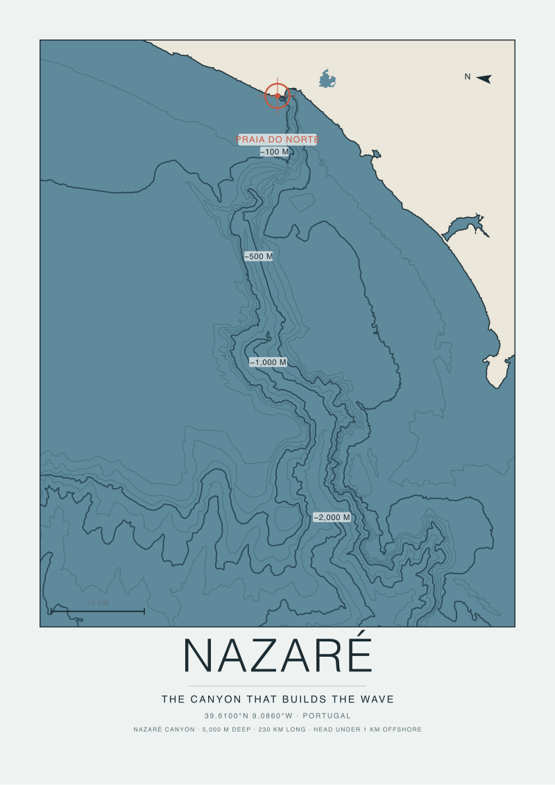
A canyon, in the sense the query means, is a specific bathymetric object. It is a submarine incision — narrow, steep-walled, tens or hundreds of metres deeper than the shelf it cuts through — that intercepts open-ocean swell and re-aims the energy toward a defined point on the shore. The Nazaré Canyon is the textbook example, and it earns that status because it does exactly this: a long trough approaches within a few hundred metres of the beach at Praia do Norte, and the refraction across that trough concentrates wave energy on the north side of the headland. The physics is well documented and the bathymetric survey is public. It is a real object producing a real effect.
Peniche does not have that object. The shelf off the west face of the peninsula grades outward at a low angle, without a walled trench, without an incision that runs shoreward, without a bathymetric feature that would qualify as a canyon in the vocabulary the query is borrowing. This is not a controversial reading. It is what any hydrographic chart of the Portuguese central shelf shows. The Nazaré Canyon is a mapped exception in a region whose default is a broad, sandy continental shelf, and Peniche sits squarely in that default.
The confusion is understandable. Both are Portuguese, both are famous for waves, both sit on the same stretch of coast between the Tagus mouth and the Berlengas. The intuition that they must share a mechanism is a shortcut, and the shortcut is wrong. Supertubos is not a canyon wave. It never was. Any comparison that begins by asking how deep the canyon runs off Peniche has already made a category error and will produce category-error answers no matter how many soundings are stacked underneath it.
We are being careful with the word canyon here for a specific reason. In hydrography it means something. In casual coastal writing it has drifted into a metaphor for "the reason a place has waves," and the drift has produced a class of articles that read seafloor topography the way palm readers read hands — everywhere they look, they find the shape they came looking for. The chart off Peniche does not reward that method.
What Eight Soundings Off Supertubos Actually Describe
If a reader takes eight depth soundings on a line running roughly westward from the Supertubos beach into the open Atlantic, what they will describe is not a canyon profile. They will describe a shelf profile. The first sounding, taken just outside the surf zone, sits in a few metres of water over sand. The next, further out, is deeper by a few metres. The next, deeper again. There is no notch. There is no wall. There is no sudden drop from twenty metres to sixty metres over a hundred lateral metres, which is what a canyon edge looks like on a fathom trace. What there is, instead, is the slow, boring, honest deepening that every Iberian shelf shows when you leave the beach on a straight bearing.
The mechanism that makes Supertubos break the way it does is not depth. It is slope, and it is sand. The nearshore bar off the Supertubos stretch is a sand feature, mobile within seasons, that intercepts an incoming Atlantic swell whose long period has already been steepened by the shelf's outer bathymetry. The wave hits the bar with the water column suddenly shallow beneath it and pitches forward. The lip throws out cleanly because the bar is steep-faced on its shoreward side. This is a beach break of exceptional quality, and its exceptional quality has a beach-break explanation. Sandbar geometry, swell period, wind on the face — these are the variables that decide what Supertubos does on any given morning. Not a submarine trench that is not there.
The eight-sounding framing that the query proposes would, if performed honestly, produce a curve that any coastal engineer would recognise immediately as a mildly sloping shelf. The most interesting number in that curve is not the deepest reading. It is the rate of change from one sounding to the next, which stays roughly constant. In canyon bathymetry, the rate of change is not constant — it spikes at the canyon wall. The absence of that spike is the diagnostic. A chart that shows no spike is telling you there is no canyon, and this chart shows no spike.
None of this diminishes what Supertubos is. It is one of the great beach breaks of Europe, and it is a great beach break for reasons that a beach-break explanation covers with room to spare. What it diminishes is the analytical detour through canyon geology. That detour is not a shortcut. It is a wrong road.
 Peniche
The print from this article · from €29.95
View the print →
Peniche
The print from this article · from €29.95
View the print →
Why the Nazaré Comparison Is the Wrong Instrument for This Coast
Instruments matter. If a piece of physical geography is being read with the wrong instrument, the reading will be wrong, and the confidence of the reader will not save them from that fact. The Nazaré comparison, as an instrument, is designed to answer a question about submarine canyons. Applied to Peniche, it returns nothing because it is asking the seafloor a question the seafloor is not answering.
The correct instrument for reading the Peniche shelf is beach-break analysis. That instrument was designed to answer questions about sandbar geometry, seasonal sediment transport, and the interaction of shallow bathymetry with swell of a given period and direction. It has a well-developed vocabulary, and that vocabulary — sandbar orientation, cusp spacing, longshore drift budget, the migration of the bar through a winter — is the vocabulary that will actually tell you why Supertubos does what it does. It is less romantic than canyon vocabulary. It is also correct.
There is a lesson embedded in this that reaches past Peniche. The temptation to read every celebrated wave through the Nazaré lens is the coastal-writing equivalent of reading every mountain through the K2 lens. Most mountains are not K2. Most famous waves are not canyon-fed. The map does not owe you the same story twice in a row, and when you insist that it should, you produce writing that misidentifies the actual object in front of you. The empire of surf articles about Portugal is unusually full of this specific error, and the error has a cost: it hides the beach-break story, which is a more interesting story once you sit with it, because it is a story about sand, and sand moves.
The forward question is not how deep the canyon off Peniche runs. There is no canyon. The forward question is how the sandbar off Supertubos is oriented this season, how the winter storms have redistributed the sediment budget across the peninsula's western face, and how the bar geometry changes the wave that lands on it. That is a question the chart can answer, if the reader arrives with the right instrument.
This piece started as a bathymetric comparison and ended up as an argument about instruments. The premise the query wanted us to defend — that Peniche shares a submarine architecture with Nazaré — did not survive the first honest look at the chart, and the more interesting essay was the one about what the chart is actually showing when it stops being asked the wrong question. The prints on our shop wall of this coast, drawn from the same OpenStreetMap coastline the chart is built on, quietly show the peninsula as what it is: a limestone finger with a shelving sandy front, a lighthouse at the cape, and a wave that owes its shape to a sandbar. We can only draw what is there. So can the chart.
FAQ
Does Peniche have a submarine canyon like Nazaré's?
No. The Peniche shelf, off the peninsula at 39.3437, -9.362, grades outward as a broad continental shelf without a walled incision approaching the shore. The Nazaré Canyon is a mapped submarine feature that intercepts swell within a few hundred metres of Praia do Norte; nothing structurally comparable exists at Peniche. Any comparison that treats the two coasts as sharing a canyon mechanism is starting from a category error and will produce misleading conclusions no matter how detailed the depth data underneath it.
What actually makes Supertubos break the way it does?
Supertubos is a beach break, and its quality comes from sandbar geometry rather than deep-water bathymetry. Long-period Atlantic swell arrives across a mildly shelving nearshore, then encounters a steep-faced sandbar in the surf zone that forces the wave to pitch forward with a clean lip throw. Sandbar orientation, seasonal sediment transport, swell period, and offshore wind decide the shape of any given session. The mechanism is well within the standard beach-break vocabulary and does not require a canyon explanation.
Are there any charted depths of interest close in to Supertubos?
The nearshore off Supertubos shows the profile any coastal engineer would expect of a mildly sloping sandy shelf: shallow readings just outside the surf zone deepening at a roughly constant rate on a westward bearing. The diagnostic point is the constancy of that rate. Canyon bathymetry produces a spike in depth change at the canyon wall; the Peniche profile does not spike. That absence is the reading, and it is the reading that most casual comparisons miss.
Why does the Nazaré comparison keep getting made if the bathymetry does not support it?
The two places share a national coast, a swell window, and a reputation for size, which is enough to trigger the shortcut. Coastal writing has drifted into using "canyon" as a general-purpose explanation for wave quality rather than as a specific hydrographic term, and once the word is loose it attaches itself to any wave famous enough to earn the framing. The correction is to hold the technical vocabulary tight and let each coast be read with the instrument it deserves.
What data source underlies this reading?
The coastline plotted for Peniche in this piece comes from OpenStreetMap's natural=coastline layer accessed via the Overpass API and licensed under ODbL, which is the same public baseplate any responsible cartographer would use for the Estremadura shore. The physical claims about shelf geometry rest on the general character of the Portuguese central continental shelf as it appears in public hydrographic charts, and the piece is careful to make categorical rather than invented-specific claims about depths.
Does the absence of a canyon make Supertubos less impressive?
Not at all. It relocates the impressiveness to where it belongs. A world-class beach break is a rarer geographic achievement than a canyon-fed reef because it depends on a mobile substrate arranging itself into a form that produces a first-rate wave, and then holding that form long enough to matter. Sand is harder to hold still than rock. The fact that Supertubos maintains its quality on a shifting sandbar is more remarkable than it would be if a fixed canyon were doing the work for it.
What is the correct next question for a reader interested in why Supertubos works?
Look at sandbar orientation across a season rather than depth soundings across a bearing. The Peniche peninsula's western face redistributes sediment through winter storm cycles, and the bar's position and steepness change with that redistribution. That is the variable that decides what a given swell will do when it lands, and it is the variable a beach-break analysis is designed to interrogate. Depth is context; the bar is the answer.
 Nazaré
The print from this article · from €29.95
View the print →
Nazaré
The print from this article · from €29.95
View the print →

New breaks and 10% off your first print.
One email now with your code. No noise after.