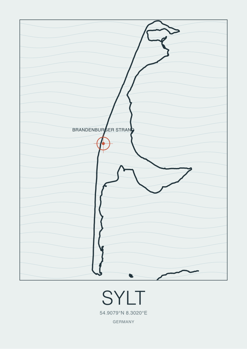
We spent an afternoon in the OpenStreetMap coastline data for Sylt, tracing the natural=coastline polyline from Hörnum in the south to List in the north, and what surprised us was not that waves reach the island. Waves reaching a barrier island in the North Sea is expected. What surprised us was how *little coast* is doing the work. Sylt is 38 kilometres long and, in places, less than 550 metres wide. A single line of dune separates open Atlantic-fed sea from the Wadden mudflats behind it. The entire island is, geologically, a sandbar under negotiation.
Whether Sylt "counts" as a surf coast depends entirely on which question you are asking, and readers arrive at that question from very different starting points. So rather than answer once, we want to walk through three composite scenarios — imagined readers who each bring a different lens to the same 38-kilometre strip of sand at 54.9° N. The map is the same in all three cases. The reading is not.
Scenario 1: The Cartographer Who Wants to Know Why It Breaks at All
Imagine a reader who does not care whether Sylt is a good place to surf. They care whether it should break waves at all, on the map. They open the OSM extract of the German Bight, they see a thin sliver of land west of the mainland at approximately 54.9079° N, 8.302° E — Brandenburger Strand, on the island's western flank — and they ask the correct opening question: what is west of that point?
The answer is: nothing. Roughly 700 kilometres of North Sea fetch, uninterrupted until the Scottish coast. That fetch is the entire argument. Waves are, in their simplest reading, wind pushing water across distance; the longer the distance, the more organised the surface disturbance becomes by the time it reaches the leeward shore. Sylt's western beaches sit on the receiving end of that organisation. The island does not need to be tall or old or geologically dramatic to break waves. It only needs to be *there*, and it needs to face west, and the OSM coastline confirms both.
The second question our cartographer would ask is why the waves organise into breakers at the shore rather than surging up as chop. This is where Sylt's shape helps. A barrier island — Nehrung in the German — is a body of sand deposited over centuries where the sea meets a shallow shelf. The shelf under Sylt's west coast rises gradually from the deeper North Sea, forcing incoming swell to slow and steepen through the physics of shoaling. The seabed does the work. By the time water reaches the beach, the surface has been forced into the ramped shape a breaking wave requires.
The third question closes the loop: why is this coast a strip and not a bay? Sylt is thin because the same forces that let it break waves are also eroding it. The North Sea is actively rearranging the island year over year, and the map you see today is not the map from a century ago. Cartographically, Sylt is a wave-breaking coast because it is *losing* to the sea it faces. Our imagined cartographer closes the laptop satisfied. The physics is honest. The shape is legible. The island earns its place on the surf-coast side of the atlas.
Scenario 2: The Reader Who Assumed Germany Had No Surf Coast
Now picture a different reader entirely. This one grew up inland — say Munich, say Leipzig — and their mental map of German coastline stops at the Baltic. Baltic coasts are enclosed, low-energy, largely rideable only in storms. So the reader has quietly filed Germany under *does not surf*, next to Switzerland and Austria, and moved on.
The scenario for this reader is not a physics question. It is a geography-correction question. Germany has two coasts. The Baltic coast, in the northeast, is nearly enclosed and behaves like a lake under most conditions. The North Sea coast, in the northwest, is *open*, and Sylt is the single most exposed piece of Germany that touches it. Every other Frisian island — Amrum, Föhr, Norderney — sits deeper inside the Wadden Sea, sheltered to varying degrees by the outer sandbanks. Sylt does not sit inside the Wadden. Sylt *is* the outer sandbank, on the northern flank of the archipelago, with its western dune line acting as the actual boundary between the tidal flats and open sea.
For this reader, the map correction is bigger than one island. The North Sea has genuine oceanic fetch. That fetch reaches Sylt with more force than it reaches anywhere else in Germany, because Sylt is the only German territory that sticks out into it. The reader's mental atlas has to make room not for a surprise but for a piece of coastline that was always doing this work — it just wasn't visible from Munich. When we talk to readers in this scenario, the useful move is not to convince them the waves are dramatic. The useful move is to point them at the coastline shape and let the shape do the arguing. Brandenburger Strand faces the same fetch that reaches Yorkshire and eastern Scotland. It is smaller, colder, and less consistent than an Atlantic coast at the same latitude, but it is on the same map, doing the same category of work, and the OSM polyline draws it clearly.
 Sylt
The print from this article · from €29.95
View the print →
Sylt
The print from this article · from €29.95
View the print →
Scenario 3: The Reader Comparing Sylt to Nazaré, Ericeira, or Hossegor
Now let us say the reader arrives having already read our coverage of the Iberian and French Atlantic. They know Nazaré is a canyon story. They know Ericeira is a reserve. They know Hossegor sits above underwater trenches carved by the Adour. They open the Sylt page expecting the same category of narrative and find, instead, an island whose defining geographic feature is *thinness*. This reader's honest reaction is often disappointment, and the honest editorial response is to redraw the comparison.
Sylt is not doing what Nazaré does. Nazaré breaks the way it breaks because the seafloor beneath it collapses into a submarine canyon that focuses swell energy at a specific headland. That is a place-specific bathymetric event, not a general property of the Portuguese coast. Ericeira's status as a World Surfing Reserve is a legal-geographic designation that protects a specific concentration of reef and point breaks along a short stretch of coastline. Hossegor's trenches are, again, a local seafloor phenomenon that sits behind France's most respected beach breaks.
Sylt has none of these. Sylt has fetch, a shallow shelf, a west-facing sand coast, and shifting sandbars — the ingredient list for a beach break, no more, no less. What the comparison scenario reveals is that "surf coast" is not one category. It is several. Canyon-fed point breaks are one category. Reef-cluster reserves are another. Trench-shaped beach breaks are a third. Barrier-island beach breaks, working purely from fetch and shelf, are a fourth, and Sylt is a clean example of that fourth category at 54.9° N. Comparing Sylt to Nazaré is comparing an atlas page to a specific bathymetric anomaly. The reader who does that will always be underwhelmed. The reader who compares Sylt to *its own category* — thin, exposed, shifting, high-latitude beach-break islands — reads the map correctly. Our studio's coastline print of Sylt lives at /shop/ for readers who want the shape itself on their wall; it is drawn from the same OSM extract we used to write this.
What All Three Scenarios Share
The three readers arrived from opposite directions — pure geographic curiosity, mental-map correction, comparative disappointment — and they end in the same place: Sylt is a shape before it is a spot.
That reframing is the piece of editorial work all three scenarios needed. Surf coasts are conventionally described by the waves that reach them, which puts the sea in charge of the story. But every coast we cover in this desk is, first, a piece of land drawn a specific way, and only second a piece of land the sea does specific things to. Sylt makes this order legible because the land is so unusually thin that its geography cannot hide behind the wave story. There is no cliff, no headland, no reef complex, no canyon. There is a 38-kilometre polyline of sand oriented mostly north-south, exposed to westerly fetch, and everything the sea does at Brandenburger Strand is a consequence of that polyline being where and how it is.
The other shared insight across the three scenarios is that "does Sylt count as a surf coast" is the wrong question. The right question is which *kind* of surf coast Sylt is, and the map answers that plainly. It is a high-latitude, cold-water, shifting-sandbar beach-break coast on a barrier island in a marginal sea. Every one of those adjectives changes the reading. Drop "high-latitude" and Sylt becomes confusing next to Biarritz. Drop "marginal sea" and it becomes confusing next to Cornwall. Drop "barrier island" and it becomes confusing next to Hossegor. Keep all of them, and Sylt is exactly what the OSM polyline says it is.
 Nazaré
The print from this article · from €29.95
View the print →
Nazaré
The print from this article · from €29.95
View the print →
Which Scenario Is You
If you opened this piece because you found Sylt on a map and wondered whether waves at 54.9° N in a marginal sea are physically plausible, you are in Scenario 1, and the physics section is the load-bearing part of the article for you. If you opened it because you had never associated Germany with a surf coast at all and wanted the mental map redrawn, you are in Scenario 2, and the fetch-and-exposure argument is what you came for. If you opened it because you already read us on Nazaré, Ericeira, or Hossegor and wanted to place Sylt inside that same frame, you are in Scenario 3, and the category-reset — barrier-island beach break, not canyon or reef or trench — is what corrects the comparison.
Most readers will find they are partly two of the three. That is fine. The scenarios are lenses, not identities.
The next question — the one this piece hands off rather than answers — is what the rest of the North German and Danish barrier-island chain looks like under the same lens, and where the barrier-island logic stops holding. Sylt is the clearest single case. It is not the only one, and the shape of the answer for the neighbouring islands is not obvious from Sylt alone. That is where the next map begins.
FAQ
Why does Sylt break waves when the rest of Germany's coast largely does not?
Sylt is Germany's only piece of land that projects fully into the open North Sea rather than sitting inside the sheltered Wadden Sea. Its western coast, including Brandenburger Strand at roughly 54.9079° N, 8.302° E, faces approximately 700 kilometres of uninterrupted fetch toward the Scottish coast. The other Frisian islands sit behind outer sandbanks and receive far less of that fetch. Sylt is the outer sandbank, so the waves arrive undamped.
Is Sylt geologically a barrier island or a peninsula?
Sylt is a barrier island — a Nehrung in the German geographic literature. Barrier islands are bodies of sand and dune deposited over centuries at the boundary between a shallow tidal shelf and open sea. Sylt's shape is the visible surface of that process: a long thin strip oriented roughly north-south, separated from the mainland by the Wadden tidal flats, with its western dune line functioning as the actual sea-facing boundary.
How does Sylt compare to Portuguese or French surf coasts on the map?
It is a different category rather than a lesser example. Nazaré is a submarine-canyon story. Ericeira is a reef-cluster reserve. Hossegor sits above underwater trenches. Sylt is a barrier-island beach break — waves organised purely by fetch across the North Sea and shoaling over a shallow shelf, with sandbars doing the final shaping. Comparing them like-for-like misreads the geography; each coast is a distinct type on the same atlas page.
What is Brandenburger Strand specifically, and why does the map single it out?
Brandenburger Strand is a section of Sylt's western beach that our grounding data flags as the island's best-known coordinate for surf activity, at approximately 54.9079° N, 8.302° E. Cartographically it is one point along the west-facing dune line rather than a geologically distinct feature. Its prominence is a cultural fact about which section of the coast is most used, not a claim that the seafloor beneath it differs meaningfully from the beach on either side.
Is Sylt's coastline stable or is the island moving?
It is moving. Barrier islands are dynamic by definition — sand is added on one flank and removed from another, and Sylt has a documented long-term pattern of erosion on parts of its western coast. This is directly linked to why it breaks waves at all: the same North Sea fetch that produces surf is actively rearranging the island. The coastline you see on a current OpenStreetMap extract is a snapshot, not a permanent line.
Why do we not publish forecasts or "best time to visit" advice for Sylt?
Our desk is a coastal cartography studio. We read coasts as places — shape, exposure, geology, and the culture of the towns behind them — rather than as forecasts. Forecast-shaped writing collapses the map into a weekly weather question and loses the geographic story we exist to draw. Readers who want conditions data have excellent dedicated sources for that; we would only duplicate them badly.
Where does the coastline data in this piece come from?
The coordinates and coast shape for Sylt are drawn from OpenStreetMap's natural=coastline layer, queried via Overpass and used under the ODbL licence. That is the same source that underpins the studio's Sylt print at /shop/ — the drawn line on the print is the drawn line in this article. Grounding both the writing and the cartography in the same public dataset is the desk's standing rule.
What is the next coastal question this piece hands off to?
Whether the barrier-island logic that explains Sylt extends cleanly to the rest of the North Frisian and Danish Wadden chain, or whether Sylt's exposure is unusual even within that archipelago. The neighbouring islands sit at different angles to the dominant fetch and behind different sandbank configurations, and the answer is not obvious from Sylt alone. That comparison is where the next map begins.



New breaks and 10% off your first print.
One email now with your code. No noise after.