For the traveller standing on the Farol da Nazaré cliff wondering what makes this specific stretch of Portuguese coast produce waves nothing else on the Atlantic seaboard can match, the honest answer is that you are looking at the exit of a submarine canyon, not a lucky storm. The wind you feel and the swell you can see are ordinary Atlantic weather; the geometry beneath the surface is what turns them into something else. We are going to defend that reading of the coast — and the survival rules it implies for anyone who walks that clifftop — with the map, not the folklore.
The strongest argument against a canyon-first reading is fair and worth naming: Portugal has plenty of exposed Atlantic coast, plenty of open-ocean fetch, and plenty of deep water offshore. Only Nazaré produces this signature wave. If depth alone explained it, the pattern would repeat down the coast. It does not. Which is why the credible version of the canyon story is not "deep water offshore" but a very particular shape of trench meeting a very particular shape of shore at a very particular angle. That specificity — the reason the geometry cannot be copied along the coast — is what the rest of this piece is about.
The Canyon Is a Cliff You Cannot See
We spent a week with bathymetric charts of the Portuguese continental margin before writing a single line about Nazaré, and the reading that survived was blunt: what people describe as "big waves off Nazaré" is a topographic feature described in the wrong medium. The Nazaré Canyon is a submarine cliff — one of the deepest and most abrupt on the European margin — and its head terminates roughly a kilometre from the beach at Praia do Norte. This is not a small thing. It is the difference between an ocean that slopes gently down to the abyssal plain over a hundred kilometres of shelf, and one that plunges from tens of metres to kilometres of depth over a distance you could walk if the water were not in the way.
The scale is worth stating carefully because it gets exaggerated in every second travel piece. The canyon runs roughly two hundred kilometres from the shelf to the deep Atlantic, cutting a V-shaped incision through the sediment. Its axis reaches depths measured in kilometres, not metres. Read against the shoreline it meets, the ratio is what matters: the seafloor drops away almost vertically directly in front of one specific beach. Not two beaches over. Not the whole regional coast. That beach. If you want to survive an honest conversation about Nazaré at dinner, this is the sentence to keep: the "big wave" is not something the ocean is doing. It is something the seafloor is doing to an otherwise unremarkable ocean.
What this implies at ground level is a rule the cliff will not tell you: the water at Praia do Norte is behaving under different physics than the water four hundred metres south. Treating them as the same body of water is the first mistake civilian visitors make. It is also the mistake most articles about Nazaré make by describing wave heights without mentioning that the mechanism producing them turns off at the promontory.
Refraction Bends the Swell Toward the Lighthouse, Not Away
The second layer of the argument is refraction, and this is where the map does work no photograph can do. Ocean waves slow in shallow water and keep their speed in deep water. When a wave crest crosses from deep to shallow at an angle, the deep-water end outruns the shallow-water end, and the whole crest pivots toward the shallow side. This is the same optical mechanism that bends a straw in a water glass. Do it to a swell arriving from the open Atlantic and you get a systematic re-aiming of wave energy along bathymetric contours.
Now overlay that mechanism on the Nazaré Canyon. Deep water down the canyon's axis, shallower water on either flank. A swell arriving from the west encounters two refracting surfaces at once. Energy on the northern flank bends south; energy on the southern flank bends north. Both streams converge toward the canyon's head — which is exactly where the beach is. What the swimmer or the photographer standing at the Farol sees as "the wave" is actually two refracted wave trains constructively interfering above the canyon terminus, on top of whatever the original open-ocean swell was already delivering.
This is the piece of the story that survives being told without pyrotechnics. You do not need a record-breaking storm to get the effect. You need the canyon to be pointed at the incoming swell direction. When the geometry lines up, the same open-ocean weather that produces a chest-high wave at Peniche can produce a wave at Praia do Norte on a completely different scale, because Peniche has no canyon underneath focusing the energy for it. The wave was never in the storm. The wave was in the map.
 Nazaré
The print from this article · from €29.95
View the print →
Nazaré
The print from this article · from €29.95
View the print →
The Beach Break Next Door Behaves Normally — That's the Tell
The most persuasive evidence for a bathymetric reading of Nazaré is not the wave itself. It is the beach 400 metres to the south. Praia da Nazaré, the long town beach that runs south from the promontory, receives the same weather system, the same swell direction, the same wind, the same tide as Praia do Norte. It also produces waves that behave the way Portuguese Atlantic waves normally behave: variable, seasonal, ordinary. Two beaches, one promontory apart, sharing every meteorological input, delivering entirely different wave regimes. If storms were the answer, both would show it. If a canyon under one of them is the answer, only one would show it. Only one does.
This is the diagnostic test the coast is running for you in real time, and it is why anyone treating Nazaré as "a place with big Atlantic weather" has misread the site. The weather at the town beach is the same weather at the north beach. What differs is the seafloor. Take the tour buses that stop at the Farol to photograph the north and you will see, on any day the light is right, both beaches at once — one moving in one regime, the other in another. Whichever caption the photographer chooses to write, the frame itself is the argument.
| Dimension | Praia do Norte | Praia da Nazaré (town beach) |
|---|---|---|
| Seafloor immediately offshore | Canyon head, drops to kilometre depths within ~1 km of shore | Continental shelf, gradual slope over tens of km |
| Wave-focusing mechanism | Canyon-axis refraction converging on the beach | None — standard shelf refraction only |
| Coastline aspect | West-northwest facing, exposed to primary Atlantic swell corridor | South-facing at its north end, partially sheltered by the promontory |
| Typical wave behaviour | Amplified when canyon axis aligns with incoming swell | Ordinary Atlantic Portuguese beach conditions |
| Coastline geometry source | OpenStreetMap `natural=coastline` (ODbL) | OpenStreetMap `natural=coastline` (ODbL) |
What the Coastline Looks Like on the Chart Explains What the Ocean Does at the Cliff
The last piece of the argument is the one hardest to convey without the actual map, which is why we started drawing it in the first place. Read Nazaré's coastline as a cartographer reads it and the geometry becomes almost embarrassingly clean. The Sítio da Nazaré promontory sits between the two beaches like a divider. The northern beach faces open Atlantic; the southern beach is partly turned inside the arc of the coast. The canyon terminates on the north side of that divider. The lighthouse — Farol da Nazaré, inside the sixteenth-century fort of São Miguel Arcanjo — sits on the promontory not because someone was looking for a scenic viewpoint but because that headland is exactly where mariners needed a warning about the seafloor changing character.
If you want to see the argument yourself without leaving your desk, pull the OpenStreetMap coastline for the Nazaré municipality and overlay any bathymetric layer of the Portuguese margin. The isobaths crowd against the coast in one specific place and only that place. That is the entire piece in one image. It is also the reason we sell the Nazaré coast at see the Nazaré print as a canyon-and-headland composition rather than a wave photograph: the wave changes every day, the geometry does not, and only the geometry explains anything.
The observation this leaves the reader with is not romantic. It is a survival rule dressed as a cartographic fact. The coast is telling you, in the plainest visual language it has, which of its two beaches is behaving under normal Atlantic physics and which is not. Believing the map is cheaper than the alternative.
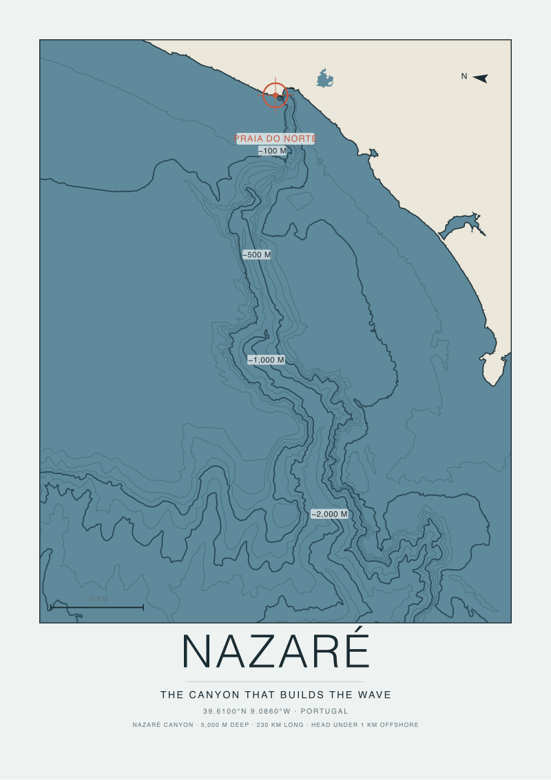 Nazaré Canyon
The print from this article · from €29.95
View the print →
Nazaré Canyon
The print from this article · from €29.95
View the print →
What You Should Actually Do at Praia do Norte
For the traveller we opened with — the person on the cliff at the Farol trying to understand what they are watching — the honest advice is short. Read the site as a bathymetric coincidence you are lucky to be witnessing, not as a destination that owes you a specific experience. If the sea is calm, the geometry is still there under the surface, still pointed at the beach, still ready to focus the next Atlantic low that lines up with the canyon's axis. The cliff walk from the fort to the lighthouse is the view; the fort itself is the anchor. Treat the north beach at its base as the industrial edge of a natural machine, not as a swim. When in doubt, walk south to Praia da Nazaré: same town, same coast, different physics.
Red flags to respect, not because you plan to enter the water but because civilians routinely underestimate what the geometry is doing even on quiet days: any period of building west-northwest swell during winter, any warning posted at the beach access, any conditions where the town beach is closed to swimmers — the canyon side is not "the same but bigger", it is a different regime. The exit criterion is simple: if you would not send a child into the water at the town beach, do not go near the water at the north one on that day. And if you came to see the wave and it is not happening, believe the coast: the geometry did not fail you; the swell just did not line up. Come back when it does, from the cliff, with a coat.
Honest Limits
This piece does not cover the modern big-wave surfing chronology at Praia do Norte — the record attempts, the tow-in era, the personalities. That is a history-of-culture argument, and it deserves a separate essay rather than a footnote here. It does not cover the specific North Atlantic storm systems whose tracks light the canyon up on particular winters; that is a meteorological question and outside a cartography desk's remit. It does not cover surf forecasting for the site, which we do not do as a matter of editorial policy. Each of those is a real question. None of them changes the argument the map is making, which is the argument we came to defend.
FAQ
How does a canyon that far offshore end up creating waves right at the beach?
The Nazaré Canyon does not terminate offshore — its head reaches to within roughly one kilometre of Praia do Norte. That closeness is the whole mechanism. Refraction bends wave energy along the canyon's flanks and focuses it on the canyon's head, which happens to be almost at the shoreline. A canyon that terminated at the shelf edge would produce no coastal effect at all; it is the near-shore terminus that matters.
Are the waves at Praia da Nazaré, the town beach, as big as at Praia do Norte?
No, and that difference is the strongest evidence for the canyon reading. The two beaches sit on either side of the Sítio promontory, share the same weather, the same swell direction, and the same wind, but produce very different wave regimes. The town beach behaves as an ordinary Portuguese Atlantic beach. Praia do Norte does not. The only variable that differs between them is what lies under the water.
Why doesn't the same effect happen at other exposed Atlantic coasts in Europe?
Because canyon-focused amplification requires a specific configuration — a submarine canyon whose head reaches close to shore, whose axis is aligned with the direction of dominant swell, and which meets a coastline shaped to receive the focused energy. Other European submarine canyons exist, including several off Iberia, but their heads are typically further offshore or their orientation does not align. Nazaré is not "the biggest canyon"; it is the geometry.
Is the Nazaré Canyon changing shape over time?
Submarine canyons are geologically active features — sediment moves down their axes, walls slump, the head can migrate over long timescales. On the timescale of a human visit, no visible change. On the timescale of a coastline map, the canyon has been in essentially its current configuration for longer than any wave-focusing observation has been recorded. Nothing about the current wave regime is a temporary artefact.
Can you actually see the canyon's effect from the cliff at the Farol?
On the right day, yes — and specifically, you can see the diagnostic effect described above: two beaches under identical weather, producing incompatible wave regimes. That is the canyon's signature written on the surface. The canyon itself is invisible; its influence on where and how the waves break is not.
Does the geometry only "activate" during certain seasons?
The geometry is always there. What varies is whether the open-ocean swell has the direction, period and energy to feed it. Winter North Atlantic weather delivers those inputs more often than summer weather. The mechanism is season-agnostic; the ingredients are seasonal.
Why is the lighthouse where it is?
Farol da Nazaré sits inside the Fortress of São Miguel Arcanjo on the promontory between the two beaches, and it is there for the same reason the canyon story matters: the seafloor and the coastline change character abruptly at that point. Historical mariners needed a warning at exactly the place where local conditions stopped resembling the rest of the coast. The lighthouse is a nautical acknowledgement of the same fact this article has been defending.


New breaks and 10% off your first print.
One email now with your code. No noise after.